Showing posts with label maps. Show all posts

Saturday, September 15, 2012

Historical maps, their meaning and their uses


Last night's round table on the War of 1812 attracted an audience of 35, not bad for a rainy Friday night opposite a hockey game.  We had faculty, students and people from town, and they were interested enough to stick around right up to 10 pm.

One of the most interesting discussions concerned the role of Natives in the war and diplomacy of the time, and whether that role has been ignored or misrepresented, and still is.  One point at  issue was the map above, which was being used to display basic geography.  The priority of the maker was clearly to emphasize American expansion.  Notice how solid  the American states and territories look, and the lack of provincial boundaries in British territory.  Even  more remarkable is the absence of any Native settlements or territories.  This led one participant to state that the map was "false."

Yes and no, say I.  What practical meaning did the boundaries of the Mississippi Territory have in  1812?  Weren't the Creek Indian settlements attacked by Andrew Jackson a lot realer?  On the other hand the state boundaries established in the 1810s are real and practical today.

This  returns me to a point I made to my Crusade and Jihad students in our first class meeting, when I was showing them various maps depicting Christian and Muslim expansion in late antiquity and the early Middle Ages.  The maps "lied" (= "were false"), I said.

It is more accurate to say that ANY map, historical or otherwise, is very much an oversimplification for analytical or propagandistic purposes.

Thus I say that the appropriate response of a historian to a historical map is not to draw a quick conclusion but to ask more questions.

Which is pretty much what we  were doing with this map last night.

Wednesday, January 11, 2012

Europe?

Over at the New York Times blog site, Frank Jacobs has a long article on "Where is Europe?"

This nifty map is the least of it:

Thursday, January 13, 2011

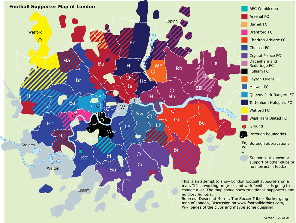
Football fans of London

I know people who will enjoy this map of London showing what districts support which teams.  Click on the map for a better view, and comment away!

Thursday, July 08, 2010

Oh, MAN! More stumbling

...over marvelous online resources.

Namely, the Digital South Asia Library, which contains a complete version of the extraordinary A Historical Atlas of South Asia; and just when I had a use for this.

Tuesday, June 22, 2010

Carnivalesque returns, and brings us Antioch

Carnivalesque, the carnival of early history blogs, is back -- over at Cranky Professor. And the first of its links takes us to Zenobia: Empress of the East, whose author Judith Weingarten, a fan of all things associated with the Eastern Empire, left in May to travel to Hatay (or Antakya), the city that now arises from the spot where the ancient Antioch once stood. To let us abandoned readers share in some of the fun she looks at an interesting Turkish initiative to reconstruct the old city. It is some challenge, because the current incarnation of the settlement is entirely modern -- if you stretch the idea of modern just a little bit. Certainly there is nothing there to suggest a city that once thought of itself as Rome's rival.

Apparently that has not stopped the Turkish scholar, Dr Kayhan Kaplan of the Department of Landscape Architecture at Mustafa Kemal University in Hatay, who at this site has posted reconstruction of what the old city may have looked like, from four different angles. It looks like the site is entirely in Turkish, but you don't have to read Turkish to enjoy this.

As Judith Weingarten points out, there are limits to this kind of reconstruction, but it gives people something to argue about, and progress is possible:
Needless to say, archaeologists and historians are going to argue about his recreations for a good many years. In fact, Antiochepedia has already thrown down the gauntlet on nine points of topography (e.g., were the river branches narrower? should the island's southern tip be more pointed? that kind of stuff). For the rest of us, it is simply stunning and gives us a real "feel" of ancient Antioch.
I agree entirely with Antiochepedia: "In the good old days, Dr Kaplan might have been cheered along the Colonnaded Street for this job!"

There is more good stuff at Zenobia, and at Cranky Professor for that matter.

Image: Antioch as depicted on the Peutinger map, a medieval copy of a Roman original.

Tuesday, December 01, 2009

Foreign forces in Afghanistan


Here's a map from the BBC that would be far more useful if it didn't divide foreign troops into only two groups -- US and NATO -- which means for instance that we can't see where Canadians are or were (they've been reassigned). Even so, it is good to have.

Tuesday, March 31, 2009

Fragmentary: the Palestinian Territories of the "West Bank," imagined as an archipelago


From Strange Maps, which quotes the creator, Julien Bousac:

The map is not about ‘drowning’ or ‘flooding’ the Israeli population, nor dividing territories along ethnic lines, even less a suggestion of how to resolve the conflict.


And SM says further:

Mr Boussac took advantage of the resulting archipelago effect “to use typical tourist maps codes (mainly icons) to sharpen the contrast between the fantasies raised by seemingly paradise-like islands and the Palestinian Territories grim reality.” The map does have a strong vacationy vibe to it – but whether that is because of the archipelago-shaped subject matter, or due to the cheerful colour scheme is a matter for debate.

Those colours, incidentally, denote urban areas (orange), nature reserves (shaded), zones of partial autonomy (dark green) and of total autonomy (light green). Totally fanciful are of course the dotted lines symbolising shipping links, the palm trees signifying protected beachland, and the purple symbols representing various aspects of seaside pleasure. The blue icon, labelled Zone sous surveillance (‘Zone under surveillance’) has some bearing on reality, as the locations of the warships match those of permanent Israeli checkpoints.

Some of the paradisiacally named islands include Ile au Miel (Honey Island), Ile aux Oliviers (Isle of the Olive Trees), Ile Sainte (Holy Island) and Ile aux Moutons (Sheep Island), although the naming of Ile sous le Mur (Island beneath the Wall) constitutes a relapse into the grimness of the area’s reality.

Sunday, December 07, 2008

Atlas of True Names (or something close)


Many place names are made up of archaic words whose meaning is not obvious. What if, suddenly, the meanings of those words were suddenly revealed and all place names were simple phrases in your language -- like, say, North Bay? Well, the map -- not to mention the insides of our heads -- might look a little different, as in the Atlas of True Names, or the excerpted map above (click to see it up close).

Thanks to Strange Maps and its alert readers for the tip. See Strange Maps for commentary and further links.

Wednesday, October 29, 2008

A useful basemap of the USA: the Electoral College


While the Greatest Show on Earth roars to its astonishing conclusion -- whatever it may be -- polls and predictions proliferate. Most graphic presentations, however, are bedeviled by basemaps that depict area rather than political clout. But the Princeton Election Consortium has avoided that trap -- voila!

Now you can go there every day and shout at the screen that they are wrong, wrong, wrong. But at least they will have a sensible basemap.

Thanks to Brad DeLong for alerting me.

Thursday, December 06, 2007

Strange Maps: The geography of blondness

Strange Maps also provided us webcrawlers recently with a link to a site, Eupedia, which includes a series of maps meant to orient the reader to some interesting features of European society. They are not all of the same quality. The map of "traditional religious majorities by region in Europe" really offends my sense of reality (see Kaliningrad). But it's still good fun.

The map above, called "The Percentage of Light Hair in Europe" is particularly neat, though I have no idea whether it has any validity. My vast background in human genetics (I have human genes, and they go back a long way!) allows me to say that this map suggests a shocking fact: a freak mutation that occurred on the shores of the Gulf of Bothnia has produced a weird looking bunch of people who have managed to convince much of the rest of humanity to bleach their hair to "fit in."

Madonna may be the current leader of this propaganda effort.

Full disclosure: In some countries I would be called blond, and my hair is lighter than most.

Strange Maps: The ancient geography of Germany


I've mentioned the unique and delightful blog Strange Maps here before; it continues to be excellent. A few days ago it ran this 19th-century reconstruction of the 1st century map of Germania (roughly modern Germany) created by the 1st century Graeco-Egyptian geographer and astronomer. Ptolemy is one of the most important scientists who ever lived. A great many of his analyses and ideas were wrong -- look up "epicycles" -- but he was a careful scholar and people were able to build better because of the foundations he laid down.

Think of this post as an homage to all who make useful mistakes.

Wednesday, June 20, 2007

Strange Maps

Andrew Sullivan's blog at the Atlantic alerts me to the existence of a blog called Strange Maps. Wow! It's already on my list of blogs to track.

The map above is what caught Sullivan's attention. It labels US states with the name of the country closest to it in Gross Domestic Product. Note that New Jersey is labeled as "Russia." This not only tells you that Russia is poorer than you think, but that New Jersey is richer.

Note that Saudi Arabia for all its supposedly fabulous wealth is only as rich as Tennessee.

Thursday, April 19, 2007

Walmart's world -- where their products come from

This relates to the last lecture in World History two weeks back. A better view at the originating site (or try clicking on the image above). I wonder what else might be there?